
Prospect topographic map
Click on the map to display elevation.
Prospect
According to the Köppen classification, Prospect is Dfb, or a humid continental climate. The town has warm and humid summers with cold winters. Precipitation is spread throughout the year, with thunderstorms frequent during the summer months, and heavy snowfalls during the winter months. Due to Prospect's elevation and location, temperatures are often colder, leading to snow in the town while lower towns to its east have rain. Like Connecticut, Prospect frequently experiences Nor'easters and Blizzards during the winter, which can bring heavy snowfall to the town.
About this map
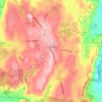
Name: Prospect topographic map, elevation, terrain.
Average elevation: 193 m
Minimum elevation: 44 m
Maximum elevation: 279 m
Other topographic maps
Click on a map to view its topography, its elevation and its terrain.
Huntington
United States > Connecticut > Naugatuck Valley Planning Region > Shelton
Average elevation: 111 m
Minortown
United States > Connecticut > Naugatuck Valley Planning Region > Woodbury
Average elevation: 169 m
Millville
United States > Connecticut > Naugatuck Valley Planning Region > Naugatuck > Union City
Average elevation: 132 m
White Hills
United States > Connecticut > Naugatuck Valley Planning Region > Shelton
Average elevation: 124 m
East Derby
United States > Connecticut > Naugatuck Valley Planning Region > Derby
Average elevation: 60 m
Mad River
United States > Connecticut > Naugatuck Valley Planning Region > Waterbury > Fair Lawn
Average elevation: 134 m
Minortown
United States > Connecticut > Naugatuck Valley Planning Region > Woodbury
Average elevation: 169 m
Bunker Hill
United States > Connecticut > Naugatuck Valley Planning Region > Waterbury
Average elevation: 140 m
Traditions
United States > Connecticut > Naugatuck Valley Planning Region > Southbury > South Britain
Average elevation: 112 m
Fox Hollow
United States > Connecticut > Naugatuck Valley Planning Region > Cheshire
Average elevation: 64 m
Bunker Hill
United States > Connecticut > Naugatuck Valley Planning Region > Waterbury
Average elevation: 140 m
Union City
United States > Connecticut > Naugatuck Valley Planning Region > Naugatuck
Average elevation: 124 m
Town Plot Hill
United States > Connecticut > Naugatuck Valley Planning Region > Waterbury
Average elevation: 127 m
Millville
United States > Connecticut > Naugatuck Valley Planning Region > Naugatuck
Average elevation: 132 m
Bunker Hill
United States > Connecticut > Naugatuck Valley Planning Region > Waterbury
Average elevation: 140 m
Westview Heights
United States > Connecticut > Naugatuck Valley Planning Region > Middlebury
Average elevation: 159 m
Warsaw Park
United States > Connecticut > Naugatuck Valley Planning Region > Ansonia
Average elevation: 107 m
Allentown
United States > Connecticut > Naugatuck Valley Planning Region > Plymouth
Average elevation: 244 m
Cedar Land
United States > Connecticut > Naugatuck Valley Planning Region > Southbury
Average elevation: 103 m
Gulls Hollow
United States > Connecticut > Naugatuck Valley Planning Region > Bethlehem
Average elevation: 243 m