
Make a donation
Gear up for your next adventure:
As an Amazon Associate, this site earns from qualifying purchases at no extra cost to you.
Gehrenberg topographic map
Click on the map to display elevation.
Make a donation
Gear up for your next adventure:
As an Amazon Associate, this site earns from qualifying purchases at no extra cost to you.
Gehrenberg
Der Gehrenberg liegt im Süden Baden-Württembergs, etwa zehn Kilometer nördlich des Bodensees. Am Fuße des Südhangs – wo auch die Brunnisach entspringt – liegt die Stadt Markdorf, andere Teile des Bergs gehören zu den Gemeinden Bermatingen, Salem, Deggenhausertal und Oberteuringen. Um von dort zum nächsthöheren Berg zu gelangen, muss man vom Gipfel aus mindestens 245 Höhenmeter absteigen (Schartenhöhe). Die Dominanz, der Abstand des Gipfels zum nächsthöheren Geländepunkt bei Wahlweiler am Hang des Höchsten, beträgt 7,4 Kilometer.
Make a donation
Gear up for your next adventure:
As an Amazon Associate, this site earns from qualifying purchases at no extra cost to you.
About this map
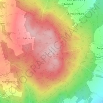
Name: Gehrenberg topographic map, elevation, terrain.
Average elevation: 651 m
Minimum elevation: 484 m
Maximum elevation: 765 m
Make a donation
Gear up for your next adventure:
As an Amazon Associate, this site earns from qualifying purchases at no extra cost to you.