Geolocate

Eger topographic map

Click on the map to display elevation.

About this map
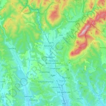
Name: Eger topographic map, elevation, terrain.

Location: Eger, Egri járás, Heves, North Hungary, Great Plain and North, Hungary (47.85697 20.31124 48.00136 20.47165)

Average elevation: 262 m

Minimum elevation: 142 m

Maximum elevation: 652 m

Other topographic maps

Click on a map to view its topography, its elevation and its terrain.
Bükk

Hungary > Heves

Average elevation: 388 m

Tiszavalki-medence

Hungary > Heves > Poroszló

Average elevation: 87 m

Eger

Hungary > Heves > Eger

Average elevation: 244 m

Liszkó gyártelep

Hungary > Heves > Sirok

Average elevation: 197 m

Gear up for your next adventure:

🥾Approach Boots - Comfortable boots for hiking and climbing approaches
🦌Outdoor Trail Camera - Monitor wildlife activity near your favorite spots
🧢Hiking Sun Hat - Wide-brimmed protection for exposed mountain ridges
🧴Sunscreen SPF - Broad-spectrum sunscreen for outdoor activities
⛺Bushcraft Tarp - Versatile emergency shelter or gear protection

As an Amazon Associate, this site earns from qualifying purchases at no extra cost to you.