Geolocate

Guantanamo topographic map

Click on the map to display elevation.

About this map

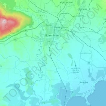
Name: Guantanamo topographic map, elevation, terrain.

Location: Guantanamo, Guantánamo, Cuba (20.01250 -75.25535 20.20836 -75.04842)

Average elevation: 51 m

Minimum elevation: -3 m

Maximum elevation: 441 m

Other topographic maps

Click on a map to view its topography, its elevation and its terrain.

Guantanamo

Cuba > Guantánamo > Guantanamo

Average elevation: 147 m

Toa

Cuba > Guantánamo > Baracoa

Average elevation: 166 m

Los Jagüeyes

Cuba > Guantánamo > Maisí

Average elevation: 369 m

Los Jagüeyes

Cuba > Guantánamo > Maisí

Average elevation: 369 m

Vega Larga

Cuba > Guantánamo > Baracoa

Average elevation: 55 m

Gear up for your next adventure:

💧Collapsible Water Bottle - Space-saving water bottle for outdoor activities
Family Camping Tent - Spacious tent suitable for family camping trips
🧭GPS Tracker - Track your location in remote areas safely
👖Convertible Hiking Pants - Zip-off legs to adapt to changing weather conditions
🧢Sun Protection Cap - Breathable cap to protect from sun exposure

As an Amazon Associate, this site earns from qualifying purchases at no extra cost to you.