
Make a donation
Gear up for your next adventure:
As an Amazon Associate, this site earns from qualifying purchases at no extra cost to you.
Cottonwood Falls topographic map
Click on the map to display elevation.
Make a donation
Gear up for your next adventure:
As an Amazon Associate, this site earns from qualifying purchases at no extra cost to you.
About this map
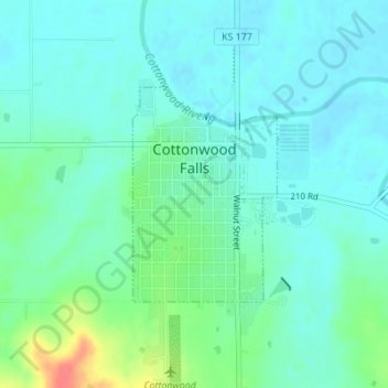
Name: Cottonwood Falls topographic map, elevation, terrain.
Location: Cottonwood Falls, Chase County, Kansas, United States (38.36225 -96.54827 38.37718 -96.53546)
Average elevation: 369 m
Minimum elevation: 355 m
Maximum elevation: 415 m
Make a donation
Gear up for your next adventure:
As an Amazon Associate, this site earns from qualifying purchases at no extra cost to you.
Other topographic maps
Click on a map to view its topography, its elevation and its terrain.
Cottonwood Falls
United States > Kansas > Chase County > Cottonwood Falls > Cottonwood Falls
Average elevation: 379 m
Strong City
United States > Kansas > Chase County > Strong City > Strong City
Average elevation: 381 m