
Vienna topographic map
Click on the map to display elevation.
Vienna
Vienna is located at 38°54′N 77°16′W / 38.900°N 77.267°W / 38.900; -77.267 (38.8991, −77.2607), at an elevation of 358 feet (109 meters). It lies in the Piedmont approximately 5.5 miles (8.9 km) southwest of the Potomac River. Wolftrap Creek, a tributary of nearby Difficult Run, flows north from its source in the eastern part of town. The Bear Branch of Accotink Creek, a Potomac tributary, flows south from its source in the southern part of town. Located in Northern Virginia on Interstate 66, Vienna is 12 miles (19 km) west of Washington, D.C. and 2 miles (3.2 km) northeast of Fairfax, the county seat.
About this map
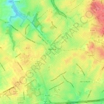
Name: Vienna topographic map, elevation, terrain.
Location: Vienna, Fairfax County, Virginia, United States (38.87854 -77.28476 38.92185 -77.24109)
Average elevation: 117 m
Minimum elevation: 76 m
Maximum elevation: 151 m