
Make a donation
Gear up for your next adventure:
As an Amazon Associate, this site earns from qualifying purchases at no extra cost to you.
Cirat topographic map
Click on the map to display elevation.
Make a donation
Gear up for your next adventure:
As an Amazon Associate, this site earns from qualifying purchases at no extra cost to you.
About this map
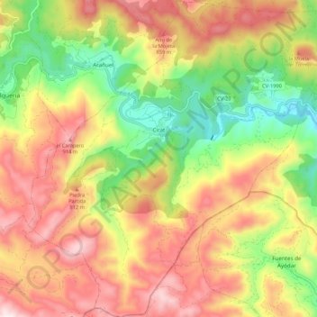
Name: Cirat topographic map, elevation, terrain.
Average elevation: 649 m
Minimum elevation: 310 m
Maximum elevation: 981 m
Make a donation
Gear up for your next adventure:
As an Amazon Associate, this site earns from qualifying purchases at no extra cost to you.
Other topographic maps
Click on a map to view its topography, its elevation and its terrain.
Benicàssim / Benicasim
Espagne > Communauté Valencienne > Castellón > Benicàssim / Benicasim > Benicàssim / Benicasim
Average elevation: 64 m
Make a donation
Gear up for your next adventure:
As an Amazon Associate, this site earns from qualifying purchases at no extra cost to you.
Fredes
Espagne > Communauté Valencienne > Castellón > la Pobla de Benifassà
Average elevation: 1,092 m
Vila-real
Espagne > Communauté Valencienne > Castellón > Vila-real > Vila-real
Vila-real est située à 8 km au sud de Castelló de la Plana, la capitale de la province, à une altitude de 42 mètres au-dessus du niveau de la mer. Elle compte 51 180 habitants, la plupart dans le noyau urbain, qui occupe 10,72 % des 55,4 km2 de la municipalité. C'est la deuxième commune la plus peuplée…
Average elevation: 42 m
la Vall d'Uixó
Espagne > Communauté Valencienne > Castellón > la Vall d'Uixó > la Vall d'Uixó
La Vall d'Uixó est située dans la vallée du Belcaire, à environ 8 km de la Costa del Azahar. D'une altitude moyenne de 118 m au centre urbain, elle est entourée par les derniers contreforts de la Serra d´Espadá, qui s'élèvent jusqu'à 648 m au Penyalba. Elle jouit des conditions climatiques typiques…
Average elevation: 196 m