Geolocate

Okuma topographic map

Click on the map to display elevation.

About this map

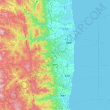
Name: Okuma topographic map, elevation, terrain.

Location: Okuma, Futaba County, Fukushima Prefecture, Japan (37.37208 140.85370 37.45020 141.29444)

Average elevation: 224 m

Minimum elevation: -1 m

Maximum elevation: 870 m

Gear up for your next adventure:

🐕Hiking Dog Pack - Let your canine companion carry their own water and food
🧣Evaporative Cooling Towel - Beat the heat during intense summer climbs
🥤Collapsible Travel Cup - Saves space and weight in your mess kit
🧴Sunscreen SPF - Broad-spectrum sunscreen for outdoor activities
🥾Mountain Hiking Shoes - Shoes with superior grip for mountainous terrain

As an Amazon Associate, this site earns from qualifying purchases at no extra cost to you.