Geolocate

Beaver Lake topographic map

Click on the map to display elevation.

About this map

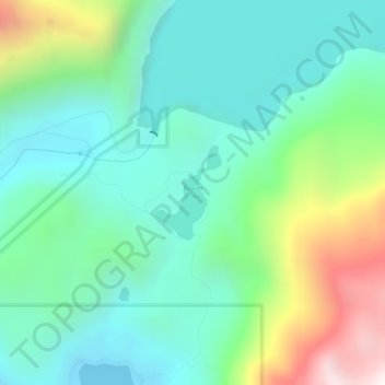
Name: Beaver Lake topographic map, elevation, terrain.

Location: Beaver Lake, Sitka, Alaska, United States (57.05488 -135.19987 57.06153 -135.19137)

Average elevation: 313 m

Minimum elevation: 0 m

Maximum elevation: 1,152 m

Other topographic maps

Click on a map to view its topography, its elevation and its terrain.

South (Middle) Sister

United States > Alaska > Sitka > Sitka

Average elevation: 368 m

Sugarloaf Mountain

United States > Alaska > Sitka > Sitka

Average elevation: 66 m

North Sister

United States > Alaska > Sitka > Sitka

Average elevation: 507 m

Clarence Kramer Peak

United States > Alaska > Sitka > Sitka

Average elevation: 751 m

Gear up for your next adventure:

🥾Hiking Shorts - Breathable shorts suitable for summer hikes
🦟Insect Repellent - Keep mosquitoes and black flies away in wooded areas
🥾Hiking Boots - Sturdy boots providing ankle support and traction on rugged trails
🥽Outdoor Goggles - Protective eyewear for outdoor activities
🥾Mountain Hiking Boots - High-traction boots for rocky terrain

As an Amazon Associate, this site earns from qualifying purchases at no extra cost to you.