
Make a donation
Gear up for your next adventure:
As an Amazon Associate, this site earns from qualifying purchases at no extra cost to you.
Lake Clarke Shores topographic map
Click on the map to display elevation.
Make a donation
Gear up for your next adventure:
As an Amazon Associate, this site earns from qualifying purchases at no extra cost to you.
Lake Clarke Shores
In the early 1930s, Zeb Vance Hooker and his family became the first settlers in modern-day Lake Clarke Shores by squatting in a wooden shack on land by the southeast side of Lake Clarke. In 1946, Patsy Renolds built a house where Antigua Road stands today and is the oldest home in Lake Clarke Shores. By the late 1940s, local attorney Walter Travers visited the area and bought the lakeshore properties from their respective owners. Travers then attempted to buy land which had been drained during the construction of the West Palm Beach Canal in the 1910s. The state of Florida initially denied his request. However, after meeting with the Trustees of the Internal Improvement Fund in Tallahassee, the board offered Travers the land for $300 per acre. Travers partially agreed but attempted to negotiate a lesser cost for land at lower elevations. The state then decided to auction the land. Travers was the only bidder and obtained 250 acres (100 ha) of land on the northwest periphery of the lake for $10,000, which a friend loaned to him. After obtaining $5,000 for an unrelated lawsuit settlement, Travers invested that money into his project to transform the area into a waterfront community and brought in dredging equipment in 1949. The fledgling community initially grew very slowly, with just three homes built by 1952. One reason for the slow growth was the lack of a bridge across the West Palm Beach Canal. Palm Beach County Commissioner Lake Lytal convinced the county commission to approve the building of a bridge, knowing that Travers intended to contribute $10,000 to its construction. The bridge, completed in 1953, connected Selby Road and Forest Hill Boulevard (State Road 882) – with the entirety of the road becoming Forest Hill Boulevard – and resulted in a quicker increase in development and population.
Make a donation
Gear up for your next adventure:
As an Amazon Associate, this site earns from qualifying purchases at no extra cost to you.
About this map
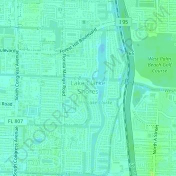
Name: Lake Clarke Shores topographic map, elevation, terrain.
Average elevation: 8 m
Minimum elevation: 4 m
Maximum elevation: 15 m
Make a donation
Gear up for your next adventure:
As an Amazon Associate, this site earns from qualifying purchases at no extra cost to you.
Other topographic maps
Click on a map to view its topography, its elevation and its terrain.
Make a donation
Gear up for your next adventure:
As an Amazon Associate, this site earns from qualifying purchases at no extra cost to you.
Make a donation
Gear up for your next adventure:
As an Amazon Associate, this site earns from qualifying purchases at no extra cost to you.
Make a donation
Gear up for your next adventure:
As an Amazon Associate, this site earns from qualifying purchases at no extra cost to you.
Loxahatchee Groves
United States > Florida > Palm Beach County > Loxahatchee Groves
Average elevation: 9 m
Caribbean Key
United States > Florida > Palm Beach County > Boca Raton > Caribbean Key
Average elevation: 5 m
Make a donation
Gear up for your next adventure:
As an Amazon Associate, this site earns from qualifying purchases at no extra cost to you.
Morikami Museum and Japanese Gardens
United States > Florida > Palm Beach County > Delray Beach
Average elevation: 9 m