
Make a donation
Gear up for your next adventure:
As an Amazon Associate, this site earns from qualifying purchases at no extra cost to you.
Duitama topographic map
Click on the map to display elevation.
Make a donation
Gear up for your next adventure:
As an Amazon Associate, this site earns from qualifying purchases at no extra cost to you.
Duitama
La altitud aproximada es de 2535 m.s.n.m. en la plaza de los Libertadores.
Make a donation
Gear up for your next adventure:
As an Amazon Associate, this site earns from qualifying purchases at no extra cost to you.
About this map
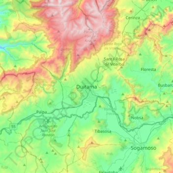
Name: Duitama topographic map, elevation, terrain.
Average elevation: 2,859 m
Minimum elevation: 2,245 m
Maximum elevation: 4,030 m
Make a donation
Gear up for your next adventure:
As an Amazon Associate, this site earns from qualifying purchases at no extra cost to you.
Other topographic maps
Click on a map to view its topography, its elevation and its terrain.
Make a donation
Gear up for your next adventure:
As an Amazon Associate, this site earns from qualifying purchases at no extra cost to you.
Barrio Bella Vista
Colombia > Boyacá > Duitama > Cabecera Municipal Duitama
Average elevation: 2,666 m