Geolocate

Keego Harbor topographic map

Click on the map to display elevation.

About this map

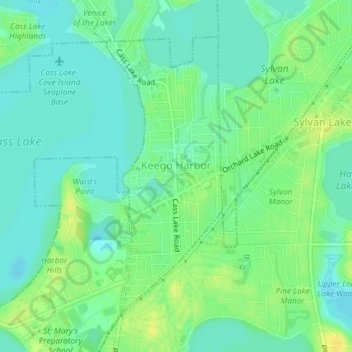
Name: Keego Harbor topographic map, elevation, terrain.

Location: Keego Harbor, Oakland County, Michigan, United States (42.59661 -83.35108 42.61793 -83.33901)

Average elevation: 286 m

Minimum elevation: 277 m

Maximum elevation: 298 m

Other topographic maps

Click on a map to view its topography, its elevation and its terrain.

Greens Lake

United States > Michigan > Oakland County

Average elevation: 309 m

Rossman Lake

United States > Michigan > Oakland County

Average elevation: 314 m

Gear up for your next adventure:

🛏️Camping Sleeping Mat - Comfortable mats for sleeping outdoors
👟Trail Running Shoes - Agile footwear for fast-paced topographic exploration
💧Hydration Pack - Hands-free hydration system for long hikes
Camping Tent - Weather-resistant tents suitable for 2 to 6 people
🥾Hiking Shoes - Durable and comfortable shoes for trail hiking

As an Amazon Associate, this site earns from qualifying purchases at no extra cost to you.