Geolocate

El Infiesto topographic map

Click on the map to display elevation.

About this map

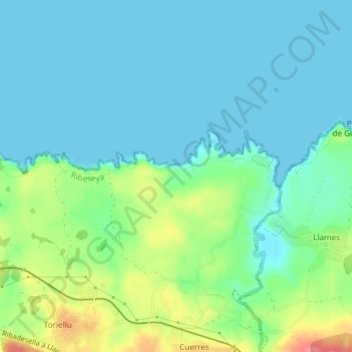
Name: El Infiesto topographic map, elevation, terrain.

Location: El Infiesto, Ribadesella, Asturias, España (43.44811 -5.00243 43.46811 -4.98243)

Average elevation: 18 m

Minimum elevation: -2 m

Maximum elevation: 72 m

Gear up for your next adventure:

🐕Hiking Dog Pack - Let your canine companion carry their own water and food
🛁Quick-Dry Microfiber Towel - Space-saving towel that dries rapidly on the move
🔪Outdoor Multitool - Versatile tool for repairs and food prep in the wild
🛶Canoe Life Vest - Safety vest for water sports
💡Portable Camping Lamp - Rechargeable lamp for campsite lighting

As an Amazon Associate, this site earns from qualifying purchases at no extra cost to you.