
Eisbergen topographic map
Interactive map
Click on the map to display elevation.
About this map
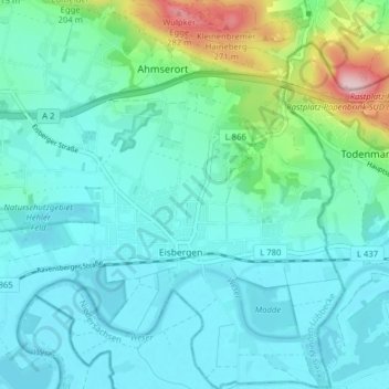
Name: Eisbergen topographic map, elevation, terrain.
Average elevation: 92 m
Minimum elevation: 47 m
Maximum elevation: 295 m
Other topographic maps
Click on a map to view its topography, its elevation and its terrain.
Holtrup
Deutschland > Nordrhein-Westfalen > Porta Westfalica
Holtrup, Porta Westfalica, Kreis Minden-Lübbecke, Regierungsbezirk Detmold, Nordrhein-Westfalen, Deutschland
Average elevation: 69 m
Gut Oheimb
Deutschland > Nordrhein-Westfalen > Porta Westfalica
Gut Oheimb, 120, Vlothoer Straße, Hitzepohl, Holzhausen I, Porta Westfalica, Kreis Minden-Lübbecke, Regierungsbezirk Detmold, Nordrhein-Westfalen, 32457, Deutschland
Average elevation: 61 m