
Make a donation
Gear up for your next adventure:
As an Amazon Associate, this site earns from qualifying purchases at no extra cost to you.
Península de Setúbal topographic map
Click on the map to display elevation.
Make a donation
Gear up for your next adventure:
As an Amazon Associate, this site earns from qualifying purchases at no extra cost to you.
About this map
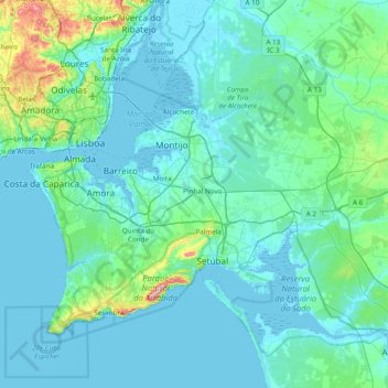
Name: Península de Setúbal topographic map, elevation, terrain.
Location: Península de Setúbal, Área Metropolitana de Lisboa, Portugal (38.40907 -9.26298 38.84542 -8.49097)
Average elevation: 45 m
Minimum elevation: -3 m
Maximum elevation: 483 m
Make a donation
Gear up for your next adventure:
As an Amazon Associate, this site earns from qualifying purchases at no extra cost to you.
Other topographic maps
Click on a map to view its topography, its elevation and its terrain.
Make a donation
Gear up for your next adventure:
As an Amazon Associate, this site earns from qualifying purchases at no extra cost to you.
Aqueduto das Águas Livres
Portugal > Área Metropolitana de Lisboa > Mina de Água
Average elevation: 155 m
Alverca do Ribatejo
Portugal > Área Metropolitana de Lisboa > Alverca do Ribatejo
Average elevation: 68 m
Make a donation
Gear up for your next adventure:
As an Amazon Associate, this site earns from qualifying purchases at no extra cost to you.
Serra da Arrábida
Portugal > Área Metropolitana de Lisboa > Azeitão > Aldeia de Irmãos
Average elevation: 96 m
Pero Pinheiro
Portugal > Área Metropolitana de Lisboa > Almargem do Bispo, Pêro Pinheiro e Montelavar > Pero Pinheiro
Average elevation: 150 m
Make a donation
Gear up for your next adventure:
As an Amazon Associate, this site earns from qualifying purchases at no extra cost to you.
Vila Nogueira de Azeitão
Portugal > Área Metropolitana de Lisboa > Setúbal > Vila Nogueira de Azeitão
Average elevation: 107 m
Barragem do Rio da Mula
Portugal > Área Metropolitana de Lisboa > Alcabideche
Average elevation: 244 m
Cortegaça
Portugal > Área Metropolitana de Lisboa > Almargem do Bispo, Pêro Pinheiro e Montelavar
Average elevation: 162 m
Quinta dos Remédios
Portugal > Área Metropolitana de Lisboa > Santa Iria de Azoia, São João da Talha e Bobadela
Average elevation: 25 m
Make a donation
Gear up for your next adventure:
As an Amazon Associate, this site earns from qualifying purchases at no extra cost to you.