Geolocate

Lebak topographic map

Click on the map to display elevation.

About this map

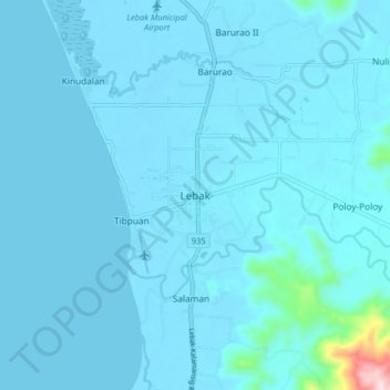
Name: Lebak topographic map, elevation, terrain.

Location: Lebak, Sultan Kudarat, Soccsksargen, Philippines (6.59367 124.02570 6.67367 124.10570)

Average elevation: 19 m

Minimum elevation: -1 m

Maximum elevation: 400 m

Other topographic maps

Click on a map to view its topography, its elevation and its terrain.

Kabulnan River

Philippines > Sultan Kudarat

Average elevation: 591 m

Columbio

Philippines > Sultan Kudarat

Average elevation: 268 m

Lutayan

Philippines > Sultan Kudarat

Average elevation: 73 m

Kapingkong River

Philippines > Sultan Kudarat > Sampao

Average elevation: 61 m

Gear up for your next adventure:

🥾Approach Boots - Comfortable boots for hiking and climbing approaches
🔥Camping Stove - Portable stoves to cook outdoors with ease
🧴Waterproofing Spray - Restore the DWR coating on jackets and tents
🧰Multitool Knife - Compact and versatile tool for outdoor use
Lightweight Backpacking Tent - Compact tent for efficient hiking trips

As an Amazon Associate, this site earns from qualifying purchases at no extra cost to you.