
Thank you for supporting this site ❤️
Make a donation
Make a donation
Gear up for your next adventure:
As an Amazon Associate, this site earns from qualifying purchases at no extra cost to you.
Altdorfer Wald topographic map
Click on the map to display elevation.
Thank you for supporting this site ❤️
Make a donation
Make a donation
Gear up for your next adventure:
As an Amazon Associate, this site earns from qualifying purchases at no extra cost to you.
Altdorfer Wald
Der Altdorfer Wald zwischen Aulendorf und Vogt im baden-württembergischen Landkreis Ravensburg ist ein bis 776,9 m ü. NHN hoher, bewaldeter Höhenzug.
Thank you for supporting this site ❤️
Make a donation
Make a donation
Gear up for your next adventure:
As an Amazon Associate, this site earns from qualifying purchases at no extra cost to you.
About this map
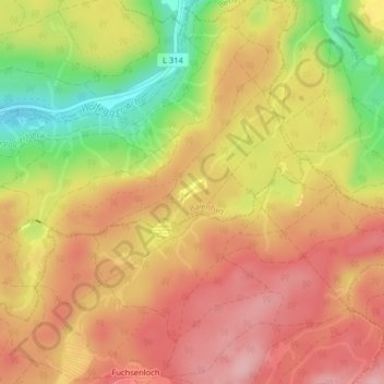
Name: Altdorfer Wald topographic map, elevation, terrain.
Average elevation: 590 m
Minimum elevation: 492 m
Maximum elevation: 653 m
Thank you for supporting this site ❤️
Make a donation
Make a donation
Gear up for your next adventure:
As an Amazon Associate, this site earns from qualifying purchases at no extra cost to you.