
Thank you for supporting this site ❤️
Make a donation
Make a donation
Gear up for your next adventure:
As an Amazon Associate, this site earns from qualifying purchases at no extra cost to you.
Refoios topographic map
Click on the map to display elevation.
Thank you for supporting this site ❤️
Make a donation
Make a donation
Gear up for your next adventure:
As an Amazon Associate, this site earns from qualifying purchases at no extra cost to you.
About this map
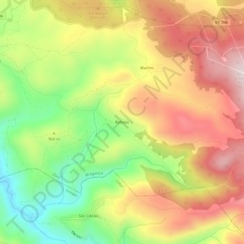
Name: Refoios topographic map, elevation, terrain.
Location: Refoios, Zoio, Bragança, Distrito de Bragança, Portugal (41.71836 -6.91319 41.75836 -6.87319)
Average elevation: 976 m
Minimum elevation: 726 m
Maximum elevation: 1,212 m
Thank you for supporting this site ❤️
Make a donation
Make a donation
Gear up for your next adventure:
As an Amazon Associate, this site earns from qualifying purchases at no extra cost to you.