
Make a donation
Gear up for your next adventure:
As an Amazon Associate, this site earns from qualifying purchases at no extra cost to you.
Granouillac topographic map
Click on the map to display elevation.
Make a donation
Gear up for your next adventure:
As an Amazon Associate, this site earns from qualifying purchases at no extra cost to you.
About this map
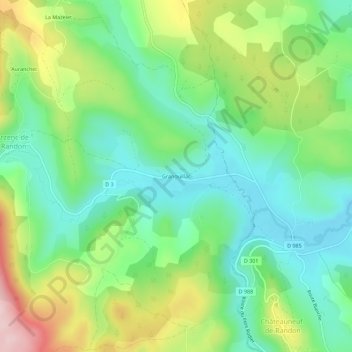
Name: Granouillac topographic map, elevation, terrain.
Average elevation: 1,224 m
Minimum elevation: 1,135 m
Maximum elevation: 1,393 m
Make a donation
Gear up for your next adventure:
As an Amazon Associate, this site earns from qualifying purchases at no extra cost to you.
Other topographic maps
Click on a map to view its topography, its elevation and its terrain.
Lac de Charpal
France > Occitanie > Lozère > Arzenc-de-Randon
Le lac de Charpal se situe à 1 326 m d'altitude, sur le socle granitique du plateau du Palais-du-Roi, dépendance Sud du massif de la Margeride, dans un secteur affaissé entre des failles par rapport aux sommets granitiques qui le dominent (1 553 m). En effet, on observe aux appuis du barrage un grès…
Average elevation: 1,345 m