Geolocate

Plaridel topographic map

Click on the map to display elevation.

Plaridel

It has an average elevation of 23 metres (75 ft) above sea level with undulating terrain. A creek is located on the western side of the area that flows to Lobog River.

Wikipedia (CC-BY-SA 3.0)

About this map

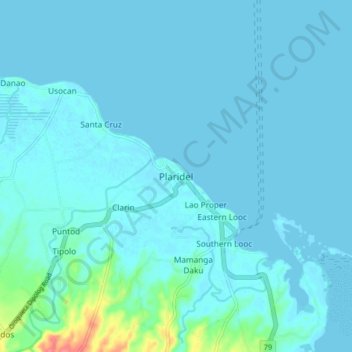
Name: Plaridel topographic map, elevation, terrain.

Location: Plaridel, Misamis Occidental, Northern Mindanao, 7209, Philippines (8.57981 123.67137 8.65981 123.75137)

Average elevation: 6 m

Minimum elevation: 0 m

Maximum elevation: 72 m

Other topographic maps

Click on a map to view its topography, its elevation and its terrain.

Bonifacio

Philippines > Misamis Occidental

Average elevation: 297 m

Ozamiz

Philippines > Misamis Occidental

Average elevation: 113 m

Tangub

Philippines > Misamis Occidental

Average elevation: 148 m

Ozamiz

Philippines > Misamis Occidental

Average elevation: 113 m

Tangub

Philippines > Misamis Occidental

Average elevation: 148 m

Ozamiz

Philippines > Misamis Occidental

Average elevation: 113 m

Ozamiz

Philippines > Misamis Occidental

Average elevation: 113 m

Ozamiz

Philippines > Misamis Occidental

Average elevation: 113 m

Gear up for your next adventure:

🛶Canoe Life Vest - Safety vest for water sports
🛏️Camping Sleeping Mat - Comfortable mats for sleeping outdoors
🧼Biodegradable Camp Soap - Environmentally friendly cleaning for gear and body
💧Filtered Water Bottle - Safe drinking water on the go
🕯️Camping Lantern - Illuminates your entire campsite with high-efficiency LEDs

As an Amazon Associate, this site earns from qualifying purchases at no extra cost to you.