Geolocate

Batac topographic map

Click on the map to display elevation.

About this map
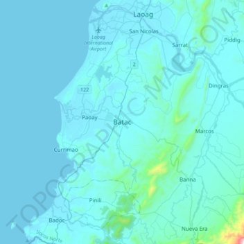
Name: Batac topographic map, elevation, terrain.

Location: Batac, Ilocos Norte, Ilocos Region, 2906, Philippines (17.89471 120.40452 18.21471 120.72452)

Average elevation: 54 m

Minimum elevation: -1 m

Maximum elevation: 1,266 m

Other topographic maps

Click on a map to view its topography, its elevation and its terrain.

Pinili

Philippines > Ilocos Norte

Average elevation: 69 m

Pagudpud

Philippines > Ilocos Norte

The town's topography includes mountains, hills, valleys and flat coastal land.

Average elevation: 73 m

Brgy. 43- Cavit

Philippines > Ilocos Norte

Average elevation: 4 m

Brgy. 11

Philippines > Ilocos Norte

Average elevation: 11 m

Brgy. 6

Philippines > Ilocos Norte

Average elevation: 10 m

Bojeador Cape

Philippines > Ilocos Norte

Average elevation: 114 m

Badoc Island

Philippines > Ilocos Norte

Average elevation: 1 m

Luna Park

Philippines > Ilocos Norte > Garreta

Average elevation: 16 m

Paoay Lake

Philippines > Ilocos Norte > Suba

Average elevation: 26 m

Saud Beach

Philippines > Ilocos Norte > Pagudpud > Saud

Average elevation: 11 m

Gasgas River

Philippines > Ilocos Norte > Foz

Average elevation: 219 m

Pagudpud

Philippines > Ilocos Norte

The topography includes mountains, hills, valleys, and flat coastal land. Maira-ira Beach is the northernmost tip of Luzon Island, located at 18°33′34″N 120°47′15″E / 18.55944°N 120.78750°E / 18.55944; 120.78750 on the Luzon Strait.

Average elevation: 73 m

Pagudpud

Philippines > Ilocos Norte

The topography includes mountains, hills, valleys, and flat coastal land. Maira-ira Beach is the northernmost tip of Luzon Island, located at 18°33′34″N 120°47′15″E / 18.55944°N 120.78750°E / 18.55944; 120.78750 on the Luzon Strait.

Average elevation: 73 m

Pagudpud

Philippines > Ilocos Norte

The town's topography includes mountains, hills, valleys and flat coastal land.

Average elevation: 73 m

Pinili

Philippines > Ilocos Norte

Average elevation: 69 m

Saud Beach

Philippines > Ilocos Norte > Pagudpud > Saud

Average elevation: 11 m

Pinili

Philippines > Ilocos Norte

Average elevation: 69 m

Brgy. 1

Philippines > Ilocos Norte

Average elevation: 10 m

Gear up for your next adventure:

🌬️Windproof Camp Stove - Efficient cooking even on exposed mountain peaks
🦶Hiking Shoe Insoles - Added support for high arches and long days on feet
🧴Sunscreen SPF - Broad-spectrum sunscreen for outdoor activities
🔦LED Headtorch - Bright and durable light for night activities
🔋Emergency Crank Radio - Weather alerts and power without needing batteries

As an Amazon Associate, this site earns from qualifying purchases at no extra cost to you.