
Melk topographic map
Click on the map to display elevation.
About this map
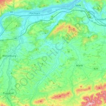
Name: Melk topographic map, elevation, terrain.
Location: Melk, Bezirk Melk, Lower Austria, 3281, Austria (48.03292 15.19781 48.23732 15.33281)
Average elevation: 320 m
Minimum elevation: 204 m
Maximum elevation: 789 m
Other topographic maps
Click on a map to view its topography, its elevation and its terrain.
Suttenbrunn
Austria > Lower Austria > Bezirk Hollabrunn > Gemeinde Hollabrunn
Average elevation: 258 m
Klosterwappen
Austria > Lower Austria > Bezirk Neunkirchen > Reichenau an der Rax
Average elevation: 1,715 m
Kirchberg an der Pielach
Austria > Lower Austria > Bezirk St. Pölten > Gemeinde Kirchberg an der Pielach > Kirchberg an der Pielach
Average elevation: 480 m
Klein-Wien
Austria > Lower Austria > Bezirk Krems > Gemeinde Furth bei Göttweig
Average elevation: 308 m
Sois
Austria > Lower Austria > Bezirk St. Pölten > Gemeinde Kirchberg an der Pielach
Average elevation: 494 m
Plackles
Austria > Lower Austria > Bezirk Wiener Neustadt > Gemeinde Hohe Wand
Average elevation: 867 m