Geolocate

Chudleigh topographic map

Click on the map to display elevation.

About this map

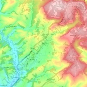
Name: Chudleigh topographic map, elevation, terrain.

Location: Chudleigh, Teignbridge, Devon, England, United Kingdom (50.58507 -3.62917 50.64604 -3.54503)

Average elevation: 129 m

Minimum elevation: 12 m

Maximum elevation: 250 m

Other topographic maps

Click on a map to view its topography, its elevation and its terrain.

Water

United Kingdom > England > Devon > Teignbridge

Average elevation: 261 m

Higher Ashton

United Kingdom > England > Devon > Teignbridge

Average elevation: 116 m

Bovey Tracey

United Kingdom > England > Devon > Teignbridge

Average elevation: 109 m

Gear up for your next adventure:

🧊Insulated Water Bottle - Keeps drinks cold in summer and prevents freezing in winter
🥾Lightweight Hiking Shoes - Comfortable shoes for day hikes
🥫Freeze-Dried Meals - Lightweight, high-calorie nutrition for multi-day treks
🛶Kayak Accessories - Essential gear for safe and fun kayaking adventures
🔥Emergency Fire Starter - Reliable ignition source for all weather conditions

As an Amazon Associate, this site earns from qualifying purchases at no extra cost to you.