Geolocate

Providencia topographic map

Click on the map to display elevation.

About this map

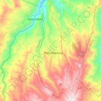
Name: Providencia topographic map, elevation, terrain.

Location: Providencia, Los Abades, Nariño, Colombia (1.17816 -77.62326 1.30603 -77.55884)

Average elevation: 2,431 m

Minimum elevation: 1,587 m

Maximum elevation: 3,363 m

Other topographic maps

Click on a map to view its topography, its elevation and its terrain.

Catambuco

Colombia > Nariño > Pasto

Average elevation: 2,874 m

Isla de la Corota

Colombia > Nariño > Pasto

Average elevation: 2,786 m

Tumaco

Colombia > Nariño > Tumaco

Average elevation: 1 m

Río Patía

Colombia > Nariño > Cumbitara

Average elevation: 568 m

Gear up for your next adventure:

🥾Mountain Trail Shoes - High-traction shoes for mountain trails
🔭Compact Monocular - One-handed bird watching and trail spotting
💡LED Camping Lantern - Illuminate your campsite with long-lasting lanterns
🧼Biodegradable Camp Soap - Environmentally friendly cleaning for gear and body
🛌Down Sleeping Bag - Superior warmth-to-weight ratio for cold nights

As an Amazon Associate, this site earns from qualifying purchases at no extra cost to you.