
Make a donation
Gear up for your next adventure:
As an Amazon Associate, this site earns from qualifying purchases at no extra cost to you.
Wallenthal topographic map
Click on the map to display elevation.
Make a donation
Gear up for your next adventure:
As an Amazon Associate, this site earns from qualifying purchases at no extra cost to you.
Wallenthal
Der Ort liegt zwischen Voißel, Stadtteil von Mechernich, und Scheven. Am Ortsrand verlaufen die Kreisstraße 27 und die Bundesstraße 266, die von Mechernich nach Gemünd führt. Durch den Ort führt der Radfernweg Eifel-Höhen-Route, der als Rundkurs um und durch den Nationalpark Eifel verläuft.
Make a donation
Gear up for your next adventure:
As an Amazon Associate, this site earns from qualifying purchases at no extra cost to you.
About this map
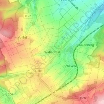
Name: Wallenthal topographic map, elevation, terrain.
Average elevation: 389 m
Minimum elevation: 302 m
Maximum elevation: 491 m
Make a donation
Gear up for your next adventure:
As an Amazon Associate, this site earns from qualifying purchases at no extra cost to you.
Other topographic maps
Click on a map to view its topography, its elevation and its terrain.
Sistiger Heide
Deutschland > Nordrhein-Westfalen > Kreis Euskirchen > Kall > Benenberg
Average elevation: 570 m