Geolocate

Bundamba topographic map

Click on the map to display elevation.

About this map

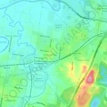
Name: Bundamba topographic map, elevation, terrain.

Location: Bundamba, Greater Brisbane, Queensland, Australia (-27.62646 152.78878 -27.58239 152.82947)

Average elevation: 33 m

Minimum elevation: 1 m

Maximum elevation: 126 m

Other topographic maps

Click on a map to view its topography, its elevation and its terrain.

White Rock

Australia > Queensland > Ipswich City

Average elevation: 114 m

Spring Mountain

Australia > Queensland > Ipswich City

Average elevation: 190 m

Stanton Cross

Australia > Queensland > Ipswich City

Average elevation: 28 m

Mount Grey

Australia > Queensland > Ipswich City

Average elevation: 231 m

Gear up for your next adventure:

🚲MTB Frame Bag - Carry tools and maps directly on your bicycle frame
🧥Thermal Layer - Insulating layer for cold outdoor conditions
🥾Lightweight Hiking Boots - Boots for comfort and mobility on long hikes
🔋Lithium AA Batteries - Long-lasting power that performs in extreme cold
🥾Mountaineering Boots - Supportive boots for climbing and high-altitude hiking

As an Amazon Associate, this site earns from qualifying purchases at no extra cost to you.