
Make a donation
Gear up for your next adventure:
As an Amazon Associate, this site earns from qualifying purchases at no extra cost to you.
Hohe Ferse topographic map
Click on the map to display elevation.
Make a donation
Gear up for your next adventure:
As an Amazon Associate, this site earns from qualifying purchases at no extra cost to you.
About this map
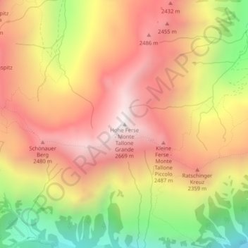
Name: Hohe Ferse topographic map, elevation, terrain.
Average elevation: 2,125 m
Minimum elevation: 1,415 m
Maximum elevation: 2,639 m
Make a donation
Gear up for your next adventure:
As an Amazon Associate, this site earns from qualifying purchases at no extra cost to you.
Other topographic maps
Click on a map to view its topography, its elevation and its terrain.
Übeltalferner
Italien > Trentino-Südtirol > Bozen > Ratschings
Auf einer Höhe zwischen 2900 m und 2800 m vereinen sich die aus den verschiedenen Karen gespeisten Gletscherarme in einem weiten, zentralen Becken zum Hauptstrom. Hier erreicht den Gletscher auch das Eis eines kleineren, nord-exponierten Beckens, das nördlich des Kammes zwischen Hofmannspitze (3113 m) und…
Average elevation: 2,991 m