Geolocate

Saybrook topographic map

Click on the map to display elevation.

About this map

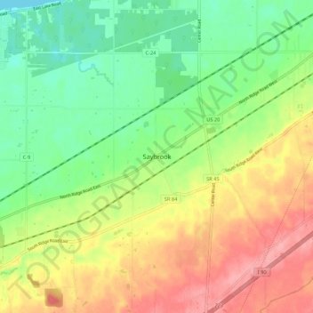
Name: Saybrook topographic map, elevation, terrain.

Location: Saybrook, Ashtabula County, Ohio, United States (41.78777 -80.91180 41.86777 -80.83180)

Average elevation: 214 m

Minimum elevation: 171 m

Maximum elevation: 267 m

Other topographic maps

Click on a map to view its topography, its elevation and its terrain.

Jefferson

United States > Ohio > Ashtabula County

Average elevation: 285 m

Roaming Shores

United States > Ohio > Ashtabula County

Average elevation: 269 m

Rock Creek

United States > Ohio > Ashtabula County

Average elevation: 248 m

Edgewood

United States > Ohio > Ashtabula County

Average elevation: 214 m

North Kingsville

United States > Ohio > Ashtabula County

Average elevation: 198 m

Ashtabula

United States > Ohio > Ashtabula County

Average elevation: 200 m

Conneaut

United States > Ohio > Ashtabula County

Average elevation: 212 m

Geneva

United States > Ohio > Ashtabula County

Average elevation: 180 m

Gear up for your next adventure:

🥾Lightweight Hiking Shoes - Comfortable shoes for day hikes
🧥Thermal Fleece Jacket - Versatile insulation for changing mountain temperatures
📷Outdoor Action Camera - Capture high-elevation views and rugged adventures
Camping Coffee Maker - Brew fresh coffee anywhere on the topographic map
🧦Hiking Liner Socks - Thin base layer to prevent friction and blisters

As an Amazon Associate, this site earns from qualifying purchases at no extra cost to you.