
Make a donation
Gear up for your next adventure:
As an Amazon Associate, this site earns from qualifying purchases at no extra cost to you.
Maroon Lake topographic map
Click on the map to display elevation.
Make a donation
Gear up for your next adventure:
As an Amazon Associate, this site earns from qualifying purchases at no extra cost to you.
About this map
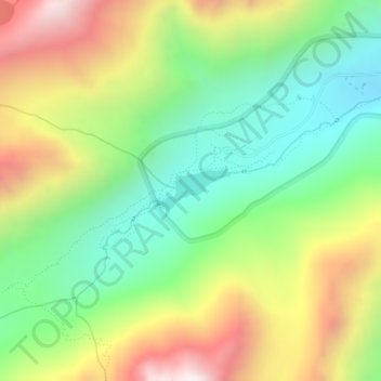
Name: Maroon Lake topographic map, elevation, terrain.
Location: Maroon Lake, Pitkin County, Colorado, United States (39.09532 -106.94838 39.09824 -106.94185)
Average elevation: 3,240 m
Minimum elevation: 2,826 m
Maximum elevation: 3,839 m
Make a donation
Gear up for your next adventure:
As an Amazon Associate, this site earns from qualifying purchases at no extra cost to you.
Other topographic maps
Click on a map to view its topography, its elevation and its terrain.
Maroon Bells
United States > Colorado > Pitkin County
Maroon Lake, elevation 2,920 m (9,580 ft), occupies a basin that was sculpted by Ice Age glaciers and later dammed by a landslide and rockfall debris from the steep slopes above the valley floor.
Average elevation: 3,691 m