
Make a donation
Gear up for your next adventure:
As an Amazon Associate, this site earns from qualifying purchases at no extra cost to you.
Hejnice topographic map
Click on the map to display elevation.
Make a donation
Gear up for your next adventure:
As an Amazon Associate, this site earns from qualifying purchases at no extra cost to you.
About this map
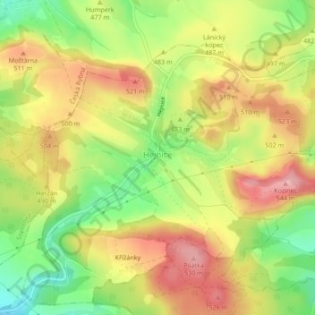
Name: Hejnice topographic map, elevation, terrain.
Average elevation: 477 m
Minimum elevation: 403 m
Maximum elevation: 541 m
Make a donation
Gear up for your next adventure:
As an Amazon Associate, this site earns from qualifying purchases at no extra cost to you.
Other topographic maps
Click on a map to view its topography, its elevation and its terrain.
Morava
Czechia > Northeast > Pardubice Region > Dolní Morava
The Morava originates in the territory of Dolní Morava in the Králický Sněžník Mountains, on the slope of the Králický Sněžník mountain at an elevation of 1,371 m (4,498 ft), not far from the border with Poland. The lowlands formed by the river are the Upper Morava Valley and then the Lower Morava…
Average elevation: 1,172 m
Králický Sněžník / Śnieżnik
Czechia > Northeast > Pardubice Region > Dolní Morava
Average elevation: 1,173 m
Make a donation
Gear up for your next adventure:
As an Amazon Associate, this site earns from qualifying purchases at no extra cost to you.