
Make a donation
Gear up for your next adventure:
As an Amazon Associate, this site earns from qualifying purchases at no extra cost to you.
Humacao topographic map
Click on the map to display elevation.
Make a donation
Gear up for your next adventure:
As an Amazon Associate, this site earns from qualifying purchases at no extra cost to you.
Humacao
Humacao is located in the southeast coast of Puerto Rico. It is bordered by the municipalities of Naguabo to the north, Yabucoa to the south, and Las Piedras to the west. The Atlantic Ocean borders the city in the east. Humacao is located in the region of the Eastern Coastal Plains, with most of its territory being flat. There are minor elevations to the southwest, like Candelero Hill, and northwest, like Mabú. Humacao's territory covers 45 square miles (117 km2). Two islands belong to Humacao: Cayo Santiago and Cayo Batata.
Make a donation
Gear up for your next adventure:
As an Amazon Associate, this site earns from qualifying purchases at no extra cost to you.
About this map
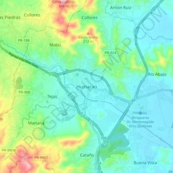
Name: Humacao topographic map, elevation, terrain.
Location: Humacao, Puerto Rico, 00792, United States (18.10918 -65.86501 18.18918 -65.78501)
Average elevation: 78 m
Minimum elevation: 0 m
Maximum elevation: 312 m
Make a donation
Gear up for your next adventure:
As an Amazon Associate, this site earns from qualifying purchases at no extra cost to you.