Geolocate

Tegat topographic map

Click on the map to display elevation.

About this map

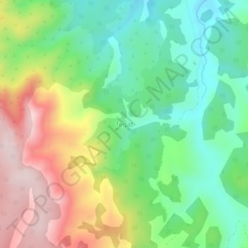
Name: Tegat topographic map, elevation, terrain.

Location: Tegat, Mauche ward, Njoro, Nakuru, Rift Valley, Kenya (-0.50997 35.88297 -0.46997 35.92297)

Average elevation: 2,801 m

Minimum elevation: 2,641 m

Maximum elevation: 3,047 m

Gear up for your next adventure:

🔋Emergency Crank Radio - Weather alerts and power without needing batteries
🔪Outdoor Multitool - Versatile tool for repairs and food prep in the wild
🧶550 Survival Paracord - Versatile utility cord for emergency repairs and rigging
🥾Trail Hiking Socks - Comfortable socks to prevent blisters and fatigue
💡Portable Camping Lamp - Rechargeable lamp for campsite lighting

As an Amazon Associate, this site earns from qualifying purchases at no extra cost to you.