Geolocate

Canton topographic map

Click on the map to display elevation.

Canton

Canton is located at an elevation of 1,060 feet (323 m). Nimishillen Creek and its East, Middle and West Branches flow through the city.

Wikipedia (CC-BY-SA 3.0)

About this map

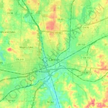
Name: Canton topographic map, elevation, terrain.

Location: Canton, Stark County, Ohio, United States (40.74366 -81.42928 40.86586 -81.28474)

Average elevation: 335 m

Minimum elevation: 301 m

Maximum elevation: 392 m

Other topographic maps

Click on a map to view its topography, its elevation and its terrain.

Mount Pleasant

United States > Ohio > Stark County

Average elevation: 352 m

Deer Creek

United States > Ohio > Stark County > Lexington

Average elevation: 319 m

Sippo Heights

United States > Ohio > Stark County > Massillon

Average elevation: 318 m

Cairo

United States > Ohio > Stark County

Average elevation: 349 m

Lake Cable

United States > Ohio > Stark County

Average elevation: 340 m

North Industry

United States > Ohio > Stark County

Average elevation: 333 m

New Franklin

United States > Ohio > Stark County

Average elevation: 365 m

Gear up for your next adventure:

🧭GPS Handheld Device - Reliable GPS navigation for outdoor adventures
🥾Approach Shoes - Shoes designed for climbing approaches and rugged trails
🧥Softshell Jacket - Windproof and breathable jacket for hiking
🧴Bear Spray Holster - Quick-access carry for essential Canadian wilderness safety
🥾Hiking Gaiters - Protect legs and shoes from mud, snow, and debris

As an Amazon Associate, this site earns from qualifying purchases at no extra cost to you.