Geolocate

Sacsayhuamán topographic map

Click on the map to display elevation.

Sacsayhuamán

Sacsayhuamán (/ˈsæksaɪˌwʌmən/ SACK-sy-wuh-mən; Spanish pronunciation: [saksajwaˈman]) or Saksaywaman (from Quechua Saksay waman pukara, pronounced [ˈsaksaj ˈwaman], lit. 'fortress of the royal falcon or hawk') is a citadel on the northern outskirts of the city of Cusco, Peru, the historic capital of the Inca Empire. The site is at an altitude of 3,701 metres (12,142 ft).

Wikipedia (CC-BY-SA 3.0)

About this map

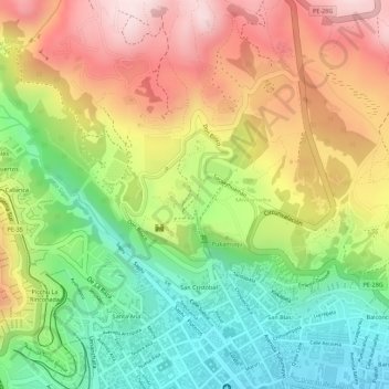
Name: Sacsayhuamán topographic map, elevation, terrain.

Location: Sacsayhuamán, Mollococha, Cuzco, Distrito de Cusco, Province of Cusco, Cusco, Peru (-13.51126 -71.98551 -13.50212 -71.97590)

Average elevation: 3,578 m

Minimum elevation: 3,373 m

Maximum elevation: 3,788 m

Gear up for your next adventure:

🧴Outdoor Sunscreen - High SPF protection for high-altitude UV exposure
🗺️Topographic Maps - Detailed maps to explore trails, mountains, and wilderness areas
🧼Travel Hand Sanitizer - Keep hands clean when water is scarce
🛁Quick-Dry Microfiber Towel - Space-saving towel that dries rapidly on the move
Tent Footprint - Protect tent floor and increase durability

As an Amazon Associate, this site earns from qualifying purchases at no extra cost to you.