Geolocate

Siradi topographic map

Click on the map to display elevation.

About this map

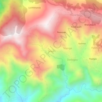
Name: Siradi topographic map, elevation, terrain.

Location: Siradi, Mangalsen, Achham, Sudurpashchim Province, Nepal (29.08115 81.23956 29.12115 81.27956)

Average elevation: 1,535 m

Minimum elevation: 974 m

Maximum elevation: 2,007 m

Other topographic maps

Click on a map to view its topography, its elevation and its terrain.

Ramaroshan

Nepal > Sudurpashchim Province > Achham

Average elevation: 2,123 m

Gear up for your next adventure:

🥾Waterproof Hiking Boots - Boots keeping your feet dry in wet conditions
👟Trail Running Shoes - Agile footwear for fast-paced topographic exploration
🥾Trail Running Shoes - Lightweight and durable shoes for trail running
🔦LED Flashlight - Powerful and long-lasting flashlight for camping and emergencies
🔦LED Headtorch - Bright and durable light for night activities

As an Amazon Associate, this site earns from qualifying purchases at no extra cost to you.