
Make a donation
Gear up for your next adventure:
As an Amazon Associate, this site earns from qualifying purchases at no extra cost to you.
Château de Valmy topographic map
Click on the map to display elevation.
Make a donation
Gear up for your next adventure:
As an Amazon Associate, this site earns from qualifying purchases at no extra cost to you.
About this map
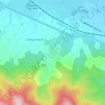
Name: Château de Valmy topographic map, elevation, terrain.
Average elevation: 94 m
Minimum elevation: 0 m
Maximum elevation: 370 m
Make a donation
Gear up for your next adventure:
As an Amazon Associate, this site earns from qualifying purchases at no extra cost to you.
Other topographic maps
Click on a map to view its topography, its elevation and its terrain.
Réserve naturelle de la forêt de la Massane
France > Occitanie > Pyrénées-Orientales > Argelès-sur-Mer
La présence du hêtre, inattendue à 600 m d'altitude en plein biome méditerranéen, la présence d'une forte biodiversité, et la naturalité de la forêt, font de la Massane un laboratoire naturel de terrain pour les chercheurs depuis plus de 100 ans.
Average elevation: 671 m
Plage naturiste du Bocal du Tech
France > Occitanie > Pyrénées-Orientales > Argelès-sur-Mer
Average elevation: 1 m
Make a donation
Gear up for your next adventure:
As an Amazon Associate, this site earns from qualifying purchases at no extra cost to you.
Hameau du Taxo d'Avall
France > Occitanie > Pyrénées-Orientales > Argelès-sur-Mer
Average elevation: 12 m