
Thank you for supporting this site ❤️
Make a donation
Make a donation
Gear up for your next adventure:
As an Amazon Associate, this site earns from qualifying purchases at no extra cost to you.
Brütten topographic map
Click on the map to display elevation.
Thank you for supporting this site ❤️
Make a donation
Make a donation
Gear up for your next adventure:
As an Amazon Associate, this site earns from qualifying purchases at no extra cost to you.
About this map
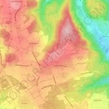
Name: Brütten topographic map, elevation, terrain.
Location: Brütten, Bezirk Winterthur, Zurich, 8311, Switzerland (47.46041 8.65147 47.49023 8.70009)
Average elevation: 581 m
Minimum elevation: 461 m
Maximum elevation: 655 m
Thank you for supporting this site ❤️
Make a donation
Make a donation
Gear up for your next adventure:
As an Amazon Associate, this site earns from qualifying purchases at no extra cost to you.