Geolocate

Aufheim topographic map

Click on the map to display elevation.

About this map

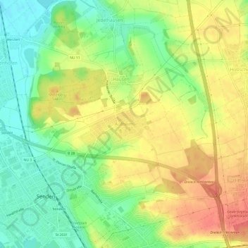
Name: Aufheim topographic map, elevation, terrain.

Location: Aufheim, Senden, Landkreis Neu-Ulm, Bayern, 89250, Deutschland (48.31685 10.04612 48.35685 10.08612)

Average elevation: 508 m

Minimum elevation: 477 m

Maximum elevation: 539 m

Other topographic maps

Click on a map to view its topography, its elevation and its terrain.

89250

Deutschland > Bayern > Landkreis Neu-Ulm > Senden > Wullenstetten

Average elevation: 511 m

Gear up for your next adventure:

🥾Lightweight Hiking Shoes - Comfortable shoes for day hikes
🥾Waterproof Trail Shoes - Shoes designed to handle wet terrain
🧢Outdoor Visor - Breathable visor for sunny hikes
🥾Light Trekking Boots - Supportive boots for multi-day treks
🧦Thermal Socks - Warm socks for winter hiking or camping

As an Amazon Associate, this site earns from qualifying purchases at no extra cost to you.