
Make a donation
Gear up for your next adventure:
As an Amazon Associate, this site earns from qualifying purchases at no extra cost to you.
Plain topographic map
Click on the map to display elevation.
Make a donation
Gear up for your next adventure:
As an Amazon Associate, this site earns from qualifying purchases at no extra cost to you.
About this map
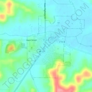
Name: Plain topographic map, elevation, terrain.
Location: Plain, Sauk County, Wisconsin, United States (43.26705 -90.05143 43.28589 -90.02824)
Average elevation: 263 m
Minimum elevation: 240 m
Maximum elevation: 339 m
Make a donation
Gear up for your next adventure:
As an Amazon Associate, this site earns from qualifying purchases at no extra cost to you.
Other topographic maps
Click on a map to view its topography, its elevation and its terrain.
Spirit Lake
United States > Wisconsin > Sauk County
Devils Lake State Park offers 29 miles of hiking trails that vary based on difficulty level, length, and terrain. Among the 17 established trails, the most popular is the tumbled rocks trail. It sits at the edge of the lake on the west end, stretching a mile long. The trail is paved, allowing it to be…
Average elevation: 349 m
Natural Bridge State Park
United States > Wisconsin > Sauk County > North Freedom
Average elevation: 289 m
Make a donation
Gear up for your next adventure:
As an Amazon Associate, this site earns from qualifying purchases at no extra cost to you.
LaValle Mill Pond
United States > Wisconsin > Sauk County > Village of La Valle
Average elevation: 292 m