
Make a donation
Gear up for your next adventure:
As an Amazon Associate, this site earns from qualifying purchases at no extra cost to you.
Rivière-Koksoak topographic map
Click on the map to display elevation.
Make a donation
Gear up for your next adventure:
As an Amazon Associate, this site earns from qualifying purchases at no extra cost to you.
About this map
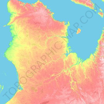
Name: Rivière-Koksoak topographic map, elevation, terrain.
Location: Rivière-Koksoak, Kativik, Nord-du-Québec, Québec, Canada (54.97462 -74.74946 62.48371 -63.31979)
Average elevation: 192 m
Minimum elevation: 0 m
Maximum elevation: 932 m
Make a donation
Gear up for your next adventure:
As an Amazon Associate, this site earns from qualifying purchases at no extra cost to you.
Other topographic maps
Click on a map to view its topography, its elevation and its terrain.
Péninsule du Québec-Labrador
Canada > Québec > Kativik > Rivière-Koksoak > Caniapiscau
Géologiquement, la péninsule du Labrador fait partie du bouclier canadien. Le mont d'Iberville, situé dans les monts Torngat qui parcourent la péninsule du nord au sud, constitue son point culminant avec 1 652 mètres d'altitude.
Average elevation: 580 m
Make a donation
Gear up for your next adventure:
As an Amazon Associate, this site earns from qualifying purchases at no extra cost to you.
Péninsule du Québec-Labrador
Canada > Québec > Kativik > Rivière-Koksoak > Caniapiscau
Géologiquement, la péninsule du Labrador fait partie du bouclier canadien. Le mont d'Iberville, situé dans les monts Torngat qui parcourent la péninsule du nord au sud, constitue son point culminant avec 1 652 mètres d'altitude.
Average elevation: 580 m