
Crossville topographic map
Click on the map to display elevation.
Crossville
Crossville occupies a high, gently rolling upland position on Tennessee’s Cumberland Plateau, giving the city a broad plateau character rather than a sharply mountainous one. Around the town center, elevations cluster near about 1,800–1,900 ft (550–580 m), with the surrounding landscape rising and falling in low ridges, shallow divides, and stream-cut hollows. The terrain is shaped by the headwaters and tributaries of the Obed River system, which become more deeply incised north of the city, where plateau streams cut into sandstone and shale to form rugged gorges, bluffs, and narrow wooded valleys. Crossville lies between the plateau’s eastern escarpment near Walden Ridge and its western transition toward the Highland Rim, so its physical setting combines an open upland surface, moderate local relief, scattered small lakes, and forested drainage corridors. Overall, the landscape has the characteristic Cumberland Plateau profile: a relatively elevated tableland, locally broken by low hills, creek valleys, sandstone-capped ridges, and increasingly rugged ravines beyond the urbanized core.
About this map
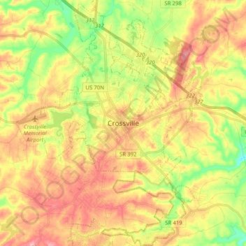
Name: Crossville topographic map, elevation, terrain.
Average elevation: 553 m
Minimum elevation: 492 m
Maximum elevation: 607 m
Other topographic maps
Click on a map to view its topography, its elevation and its terrain.
Grassland Addition
United States > Tennessee > Cumberland County > Crossville
Average elevation: 560 m
Grassland Addition
United States > Tennessee > Cumberland County > Crossville
Average elevation: 560 m