
Thank you for supporting this site ❤️
Make a donation
Make a donation
Gear up for your next adventure:
As an Amazon Associate, this site earns from qualifying purchases at no extra cost to you.
Jarol topographic map
Click on the map to display elevation.
Thank you for supporting this site ❤️
Make a donation
Make a donation
Gear up for your next adventure:
As an Amazon Associate, this site earns from qualifying purchases at no extra cost to you.
About this map
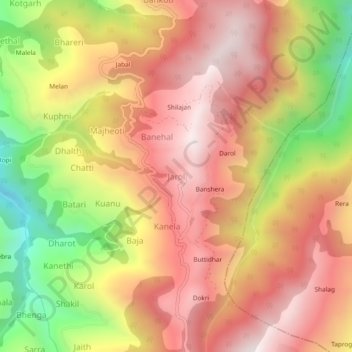
Name: Jarol topographic map, elevation, terrain.
Location: Jarol, Kumharsain, Shimla, Himachal Pradesh, 172031, India (31.27133 77.47715 31.31133 77.51715)
Average elevation: 2,219 m
Minimum elevation: 1,598 m
Maximum elevation: 2,645 m
Thank you for supporting this site ❤️
Make a donation
Make a donation
Gear up for your next adventure:
As an Amazon Associate, this site earns from qualifying purchases at no extra cost to you.