
Make a donation
Gear up for your next adventure:
As an Amazon Associate, this site earns from qualifying purchases at no extra cost to you.
Grunewald topographic map
Click on the map to display elevation.
Make a donation
Gear up for your next adventure:
As an Amazon Associate, this site earns from qualifying purchases at no extra cost to you.
Grunewald
Ortsbereich Dabringhausen: Arnzhäuschen | Bremen | Dortenhof | Emminghausen | Forthausen | Großeledder | Großfrenkhausen | Grunewald | Haussels | Heide | Höferhof | Höhe | Hundheim | Käfringhausen | Ketzberg | Ketzbergerhöhe | Kleineledder | Kleinfrenkhausen | Kleinklev | Koenenmühle | Limmringhausen | Lindscheid | Linde | Luchtenberg | Lüdorf | Maria in der Aue | Markusmühle | Neuemühle | Pantholz | Plettenburg | Rausmühle | Rölscheid | Schaffeld | Schlagbaum | Schürholz | Sondern | Steinhausen | Stumpf | Wenschebach
Make a donation
Gear up for your next adventure:
As an Amazon Associate, this site earns from qualifying purchases at no extra cost to you.
About this map
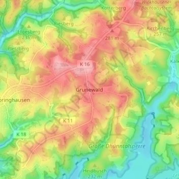
Name: Grunewald topographic map, elevation, terrain.
Average elevation: 236 m
Minimum elevation: 174 m
Maximum elevation: 298 m
Make a donation
Gear up for your next adventure:
As an Amazon Associate, this site earns from qualifying purchases at no extra cost to you.
Other topographic maps
Click on a map to view its topography, its elevation and its terrain.
42929
Deutschland > Nordrhein-Westfalen > Rheinisch-Bergischer Kreis > Wermelskirchen > Finkenholl
Average elevation: 243 m