Geolocate

Sibolga topographic map

Click on the map to display elevation.

About this map

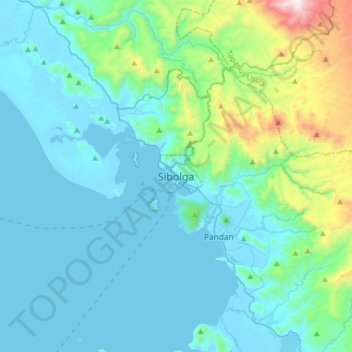
Name: Sibolga topographic map, elevation, terrain.

Location: Sibolga, City of Sibolga, North Sumatra, Sumatra, Indonesia (1.57696 98.62461 1.89696 98.94461)

Average elevation: 216 m

Minimum elevation: -2 m

Maximum elevation: 1,502 m

Gear up for your next adventure:

🩹Compact First Aid Kit - Pre-packed essentials for common trail injuries
🧥Waterproof Pants - Keep dry during rainy hiking conditions
🔥Camping Stove - Portable stoves to cook outdoors with ease
🎒Hiking Daypack - Lightweight and durable backpacks for day trips and excursions
🧶550 Survival Paracord - Versatile utility cord for emergency repairs and rigging

As an Amazon Associate, this site earns from qualifying purchases at no extra cost to you.