
Thank you for supporting this site ❤️
Make a donation
Make a donation
Gear up for your next adventure:
As an Amazon Associate, this site earns from qualifying purchases at no extra cost to you.
Wibrin topographic map
Click on the map to display elevation.
Thank you for supporting this site ❤️
Make a donation
Make a donation
Gear up for your next adventure:
As an Amazon Associate, this site earns from qualifying purchases at no extra cost to you.
About this map
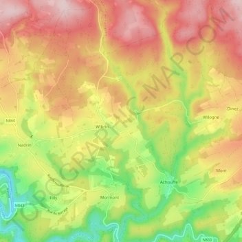
Name: Wibrin topographic map, elevation, terrain.
Location: Wibrin, Houffalize, Bastogne, Luxembourg, Wallonia, Belgium (50.13291 5.68265 50.20218 5.75562)
Average elevation: 428 m
Minimum elevation: 259 m
Maximum elevation: 578 m
Thank you for supporting this site ❤️
Make a donation
Make a donation
Gear up for your next adventure:
As an Amazon Associate, this site earns from qualifying purchases at no extra cost to you.