
Mundathanam topographic map
Interactive map
Click on the map to display elevation.
About this map
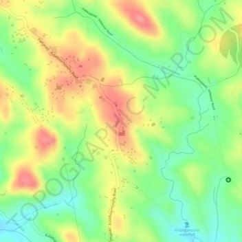
Name: Mundathanam topographic map, elevation, terrain.
Location: Mundathanam, Changanassery, Kottayam, Kerala, 686541, India (9.48463 76.69857 9.50463 76.71857)
Average elevation: 72 m
Minimum elevation: 26 m
Maximum elevation: 116 m
Other topographic maps
Click on a map to view its topography, its elevation and its terrain.
Panayampala
India > Kerala > Changanassery > Karukachal
Panayampala, Karukachal, Changanassery, Kottayam District, Kerala, India
Average elevation: 57 m
Chamampathal
India > Kerala > Changanassery
Chamampathal, Changanassery, Kottayam, Kerala, 686517, India
Average elevation: 73 m
Pathanad
India > Kerala > Changanassery > Pathanad
Pathanad, Changanassery, Kottayam, Kerala, 686542, India
Average elevation: 79 m
Changanassery
India > Kerala > Changanassery > Changanassery
Changanassery, Kottayam, Kerala, 686101, India
Average elevation: 8 m
Karukachal
India > Kerala > Changanassery > Karukachal
Karukachal, Changanassery, Kottayam, Kerala, 686540, India
Average elevation: 49 m