Make a donation
Gear up for your next adventure:
As an Amazon Associate, this site earns from qualifying purchases at no extra cost to you.
Haldimand topographic map
Click on the map to display elevation.
Make a donation
Gear up for your next adventure:
As an Amazon Associate, this site earns from qualifying purchases at no extra cost to you.
About this map
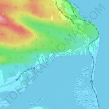
Name: Haldimand topographic map, elevation, terrain.
Average elevation: 26 m
Minimum elevation: -3 m
Maximum elevation: 138 m
La Côte-de-Gaspé trails, hiking, mountain biking, running and outdoor activities
Make a donation
Gear up for your next adventure:
As an Amazon Associate, this site earns from qualifying purchases at no extra cost to you.
Other topographic maps
Click on a map to view its topography, its elevation and its terrain.
Parc de la rue Gauthier
Canada > Quebec > La Côte-de-Gaspé > Gaspé > Val-Renard
Average elevation: 90 m
Make a donation
Gear up for your next adventure:
As an Amazon Associate, this site earns from qualifying purchases at no extra cost to you.
