
Thank you for supporting this site ❤️
Make a donation
Make a donation
Gear up for your next adventure:
As an Amazon Associate, this site earns from qualifying purchases at no extra cost to you.
Teoponte topographic map
Click on the map to display elevation.
Thank you for supporting this site ❤️
Make a donation
Make a donation
Gear up for your next adventure:
As an Amazon Associate, this site earns from qualifying purchases at no extra cost to you.
About this map
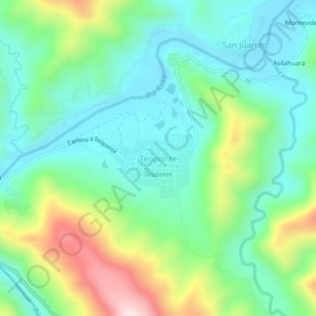
Name: Teoponte topographic map, elevation, terrain.
Location: Teoponte, Provincia Larecaja, La Paz, Bolivia (-15.51559 -67.83912 -15.47559 -67.79912)
Average elevation: 533 m
Minimum elevation: 380 m
Maximum elevation: 906 m
Thank you for supporting this site ❤️
Make a donation
Make a donation
Gear up for your next adventure:
As an Amazon Associate, this site earns from qualifying purchases at no extra cost to you.