
Eureka topographic map
Interactive map
Click on the map to display elevation.
About this map
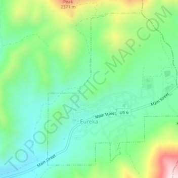
Name: Eureka topographic map, elevation, terrain.
Location: Eureka, Juab County, Utah, United States (39.94749 -112.12847 39.97063 -112.09986)
Average elevation: 2,048 m
Minimum elevation: 1,894 m
Maximum elevation: 2,396 m
Eureka is located in northern Juab County at 39°57′18″N 112°6′59″W / 39.95500°N 112.11639°W / 39.95500; -112.11639 (39.954974, -112.116364). It sits in the East Tintic Mountains at an elevation of 6,430 feet (1,960 m) above sea level. The northeast boundary of the city is the Utah County line, following the height of land. 7,828-foot (2,386 m) Packard Peak is to the north, while 8,048-foot (2,453 m) Godiva Mountain and 7,917-foot (2,413 m) Eureka Ridge are to the south.
Other topographic maps
Click on a map to view its topography, its elevation and its terrain.
Desert Mountain
United States > Utah > Juab County
Desert Mountain, Juab County, Utah, United States
Average elevation: 1,673 m
Topaz Mountain
United States > Utah > Juab County
Topaz Mountain, Juab County, Utah, United States
Average elevation: 1,895 m
Nephi
United States > Utah > Juab County > Nephi
Nephi, Juab County, Utah, 84648, United States
Average elevation: 1,651 m
Nephi
United States > Utah > Juab County
Nephi, Juab County, Utah, 84648, United States
Average elevation: 1,637 m