Geolocate

Enviny topographic map

Click on the map to display elevation.

About this map

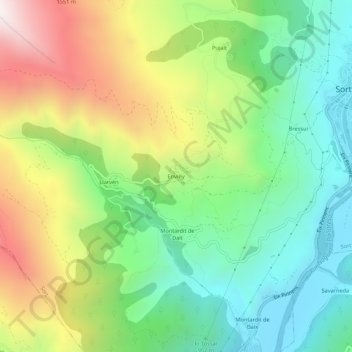
Name: Enviny topographic map, elevation, terrain.

Location: Enviny, Sort, Pallars Sobirá, Lérida, Cataluña, 25560, España (42.38152 1.08404 42.42152 1.12404)

Average elevation: 1,106 m

Minimum elevation: 651 m

Maximum elevation: 1,862 m

Gear up for your next adventure:

🛶Canoe Life Vest - Safety vest for water sports
🧴Waterproofing Spray - Restore the DWR coating on jackets and tents
🪑Ultralight Camping Stool - Compact seating for rest stops during long hikes
👟Leg Gaiters - Keep debris, mud, and snow out of your boots
💡LED Headlamp - Hands-free illumination for night hiking and camping

As an Amazon Associate, this site earns from qualifying purchases at no extra cost to you.